A Parkway was created, like it (or not, by the locals who lost their land) along this strip of the Appalachians...the southernmost end.
Wed. I went for a drive, almost in my backyard. I'd seen on the news that the Blue Ridge Parkway was again open. However the closed signs were still up as I entered, detours and all. This was around noon.
But I figured I could always turn around if I met a barrier. I didn't.
Looking back as I went home, I noticed the gates to the fence were still wide open. '
And those "closed in so many feet" signs now had been blacked out. Mmm, not a permanent feature. Me thinks it's likely just for Labor Day and the "Leaf Peepers" that the detours have been removed. Hope the fall colors bring many people back to the mountains.
And how did this all happen, you may ask?
On the curve of road right past Tanbark Tunnel, around July 17, this crack which was very deep was discovered.
As the Parkway was closed, people came to see it...
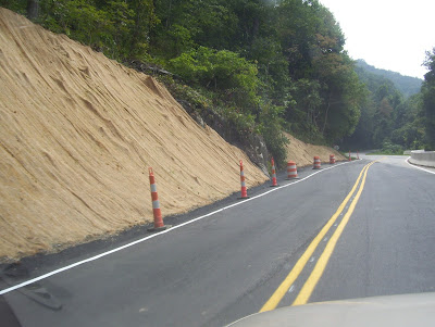
There wasn't much of a paved shoulder, but look what the engineers have come up with...
You can see where the original double line went by, and how they've added some pavement closer to the mountain.
I was glad the new roadway was on firm ground. You're only allowed to go 15 mph there, and that's it.
Here's the view coming back..
Since it's so close to the tunnel, I am glad they've got the speed reduced, because you are usually pretty blinded coming out of the tunnel, and there's the detour right away. (See the picture below where you can see the tunnel at the furthest part of the roadway.
This post is being shared with
Friday Fences HERE...I was so glad to have that concrete barrier over there where the mountain had fallen away from our abundant rain. I'll drive 15 mph any time, in order to continue along the parkway.
I'll entertain you with Craggy Gardens area tomorrow.
Quote for the day:
If you dedicate yourself to service, the doors will open.
Pir Vilayat Inayat Khan


